Home / 3D & Gaussian Splatting

Gaussian Splatting 3D Scanning in New York City

Don't just show customers your space. Let them walk through it. We capture NYC businesses as photorealistic, explore-anywhere NYC Gaussian splat tours using advanced 3D rendering, LiDAR, and 3D space scanning, delivered to any browser, phone, or headset.

Gaussian SplatsPhotoreal free-roam 3D
LiDAR ScanningRaven spatial scanner
3D ToursDollhouse, tags, floor plans
All 5 BoroughsOn-site NYC capture team

See a Gaussian Splat in Action

Explore the 2nd floor of Industrious at Fulton Center in Lower Manhattan. Drag to look around and move freely through the space, just as your customers would.

More splats, including the Buffalo AKG Art Museum, are in our 3D & 360 tours portfolio.

Our Gaussian Splat Platform

Build 3D Virtual Tours with PandaSplat

Just as the Axora360 app powers our 360° tours, PandaSplat is our own application for building 3D virtual tours with Gaussian splats. Like SuperSplat, it is built on the same splat processing backend, but it is optimized for virtual tours, with tour-based POIs and multi-floor support. Every splat on this site runs on PandaSplat.

Link multiple splats into one building tour
Multi-floor support with a spatial map
Multiple viewpoints and viewpoint POIs
Visit PandaSplat ↗

Close the Gap Between Seeing and Being There

Your customers decide online. Before they book a table, sign a lease, reserve a venue, or plan a visit, they study photos and try to picture themselves inside. Flat photos, and even traditional 360° panoramas, only get them partway. They can see what a room looks like, but not how it feels: its scale, how the light moves, what it's like to walk from the entrance to the bar or from the lobby to the corner suite.

That gap is where the next generation of virtual tours lives. 3D virtual tours, Gaussian splatting, and LiDAR-based 3D space scanning have all matured at the same time. Together, they let us hand your customers something much closer to being there: a scene that looks photographic from every angle, with real depth and real scale, that they can move through freely.

If you want customers to explore your space instead of flipping through a slideshow, this is the service for you.

Gen 1

360° Panoramas

Look around from fixed points. Fast, affordable, and published to Google Maps.

Gen 2

3D Tours & Digital Twins

Adds depth: dollhouse views, floor plans, measurements, and smooth transitions.

Gen 3

Gaussian Splats

Walk anywhere through a photoreal reconstruction, the way you would in a video game.

Advanced 3D Rendering From a Neural Capture Technique

Gaussian splatting grew out of the same research as neural radiance fields (NeRFs). Instead of a person modeling your space by hand, an optimization process learns it directly from photographs.

A Neural Capture Technique

The scene is trained, not modeled. Rendered views are compared against real photos thousands of times, and every splat is adjusted until the two match.

Advanced 3D Rendering in Real Time

Millions of soft splats blend into a photoreal image at interactive frame rates, without the slow neural networks earlier methods needed to draw each frame.

Gaussian Splatting 3D Scanning

We pair splat capture with LiDAR so every scan is photoreal and true to scale, ready for tours, floor plans, and design work.

Like SuperSplat, Built for Virtual Tours

Every splat we deliver is published on PandaSplat, our in-house system. It is built on the same splat processing backend as SuperSplat (PlayCanvas splat-transform) and opens SuperSplat's compressed files, but where SuperSplat is a general splat editor, PandaSplat is optimized for virtual tours.

Link Multiple Splats

Break a large building into several splats and join them into one seamless tour.

Multi-Floor Support

Stack every level of a building into a single tour, with a floor plan for each floor.

Spatial Map

A live spatial map shows visitors where they are and lets them jump to any scene or viewpoint on any floor.

Multiple Viewpoints

Saved viewpoints in every scene, linked so visitors glide smoothly from one to the next.

Viewpoint POIs

Viewpoint markers and tour-based points of interest anchored to exact spots in 3D: booking links, video, product cards, and more.

Guided Tours

Narrated walkthroughs with captions that take visitors through the space in the order you choose.

Four Ways to Bring Your Space Online

Every space and every goal is different. We combine these capture methods into the package that fits what you want customers to see, feel, and do.

Customer Favorite

3D Virtual Tours & Digital Twins

A true 3D tour pairs high-quality imagery with a spatial model of your space. The imagery is what customers see. The model is what makes the experience feel physical. It's the proven, mobile-friendly workhorse that turns a passive browse into active exploration.

  • Dollhouse view: spin and zoom a 3D cutaway of the whole property
  • Interactive floor plans that jump straight to any room
  • Measurements so buyers and planners can check what fits
  • Points of interest linking to menus, products, and booking
Precision

LiDAR Scanning

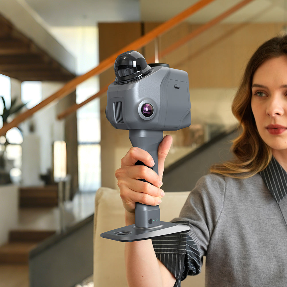
LiDAR (Light Detection and Ranging) fires laser pulses and times their return to record exact distances. Sweep it across a room and you get a point cloud: millions of precisely placed points describing every wall, column, and fixture. It's the geometric backbone that keeps photography and splats accurate and to scale. We capture with the handheld Raven LiDAR spatial scanner, which maps a space as we walk it.

  • Dimensions you can trust for planning and fit-outs
  • Floor plans you can hand to an architect or contractor
  • As-built documentation for renovations and insurance
  • Construction progress tracking against design
All-in-One

3D Space Scanning

3D space scanning is the full package: one coordinated capture that combines 360° imagery, LiDAR geometry, Gaussian splats, and photogrammetry into a single digital twin of your space. You scan once and use the result everywhere, from your website and social channels to your facilities team.

  • One site visit, multiple deliverables
  • Customer-facing tour plus measured operational model
  • Textured meshes for CAD, 3D printing, and game engines
  • A permanent digital record of your space
Raven handheld LiDAR spatial scanner with 360° camera dome, used for 3D space scanning
Our Scanner

Raven LiDAR Spatial Scanner

Our handheld Raven LiDAR spatial scanner maps your space with laser precision as we walk it. That lets us cover large restaurants, venues, and multi-floor properties in a single visit. The same pass captures the geometry behind your measured floor plans, dollhouse model, point cloud, and Gaussian splat, so every deliverable lines up perfectly.

Book a Scan
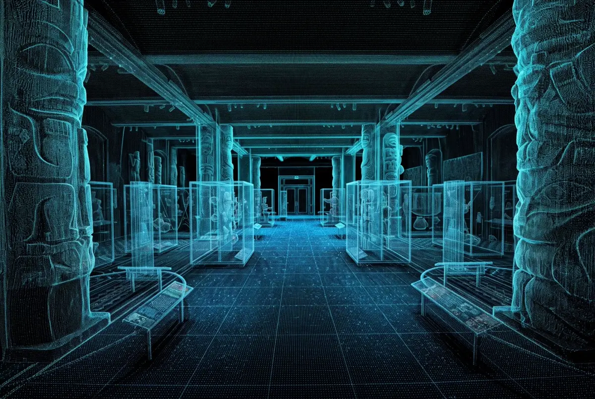
LiDAR point cloud of a museum gallery showing carved columns, display cases, and the exhibit hall in precise 3D
Example LiDAR point cloud: a museum gallery captured as millions of measured points, from carved columns to individual display cases.
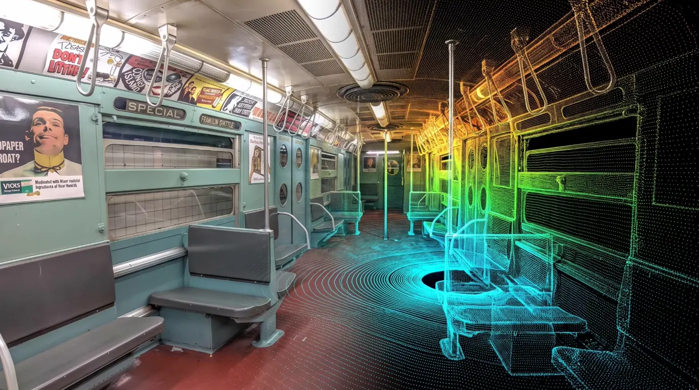
Vintage New York subway car shown as an original photo on the left blending into a color depth-mapped LiDAR point cloud on the right
Photo to point cloud: a vintage NYC subway car as the camera sees it (left) and as LiDAR measures it, color-coded by depth (right).

An Experience Customers Remember

A 360° tour shows customers what your space looks like. A Gaussian splat lets them move through it as if they were standing inside.

Example: the Gold Rush Waterpark at Double JJ Resort, captured as a Gaussian splat. Drag to explore the slides and splash zones from any angle.

Photorealism From Anywhere

Viewers glide smoothly through your space instead of hopping between fixed dots, and every angle looks like a photograph.

Premium Details, Preserved

The reflections, glass, polished stone, and soft ambient light that make high-end spaces feel high-end come through with striking fidelity.

Content That Keeps Working

A single splat produces endless camera moves: hero shots, social reels, and website fly-throughs, without booking a drone pilot or film crew again.

Ready for Spatial Computing

Because a splat is a true 3D scene, customers can stand inside it at real-world scale in VR and mixed-reality headsets.

No App Required

We optimize every capture to stream on standard phones and desktops, so anyone with a link or your website can explore it.

Longer Time on Page

Free exploration invites curiosity. Visitors linger, look around corners, and come away with a real sense of place before they ever contact you.

The honest trade-offs

Splats aren't magic. Files are larger than a standard tour, measurements from a splat alone are less reliable than from a dedicated scanner, and any area the camera never saw will look soft or broken. That's why capture planning matters, and why we pair splats with LiDAR and 360° tours when accuracy and Google visibility count.

Which Technology Does What?

Each method builds on the last. The best results usually come from combining them.

TechnologyBest atCustomer experienceLimitations
360° TourFast, affordable coverage; Google Maps & Business ProfileLook around from fixed pointsNo free movement; limited sense of depth
3D Tour / Digital TwinLayout, dollhouse, floor plans, interactive tagsExplore and understand the spaceViewpoints still tied to capture positions
Gaussian SplatPhotoreal free-roam, reflections, glass, fine detailWalk anywhere; feels like being thereLarger files; less precise for measurement
LiDAR ScanAccurate geometry, point clouds, measurementsMostly behind the scenesNot visually rich on its own

Deliverables Built for Marketing and Operations

Pick the outputs your team needs. Your marketing, sales, and facilities teams can all work from a single capture.

Embeddable Splat Viewer

A hosted, mobile-friendly experience for your website and social links.

Gaussian Splat Files

Industry-standard PLY and compressed splat formats for your own viewers or engines.

Fly-Through Videos

Cinematic camera paths rendered from your splat, cut for web and social.

3D Tour & Dollhouse

Interactive tour with dollhouse view, tags, and room-to-room navigation.

Floor Plans

Measured 2D plans generated from scan geometry.

Point Clouds

Registered LiDAR data in common formats such as E57 for AEC workflows.

Textured 3D Mesh

OBJ, glTF, or USD models for CAD, game engines, and 3D printing.

Google Business Tour

360° imagery published to Google Maps alongside your 3D experience.

From Walkthrough to Walk-Anywhere

1

Consult & Plan

We learn your goals and audience, then recommend the right mix of splat, LiDAR, and 360° capture and map out a capture route.

2

On-Site Capture

Our NYC team scans your space, ideally before opening or after close, so people moving through don't leave artifacts.

3

Process & Optimize

We align imagery and scan data, train your splat, clean up the scene, and optimize it to stream smoothly on phones.

4

Publish & Share

You get your embeddable experience, files, and videos, plus help placing them on your website, Google profile, and listings.

Built for Businesses Where the Space Sells

The more a customer's decision depends on how a place feels, the more valuable it is to let them move through it freely.

Hotels & Hospitality

Guests drift from the lobby to the rooftop bar and into a suite, and see the view from their exact room category, before they book.

Restaurants & Event Venues

Planners walk the room, check sightlines to the stage, and picture a seated dinner versus a reception, all without a site visit.

Real Estate & Luxury Residential

Out-of-town buyers explore with confidence, while agents rely on LiDAR-backed floor plans and measurements.

Retail & Showrooms

Shoppers browse your store the way they would in person, with product tags anchored to the actual shelves.

Museums & Galleries

Preserve exhibits permanently and open them to a global audience in a way flat photos never could.

Construction & Facilities

Accurate scans document existing conditions, track progress, and cut down on return site visits.

Schools & Universities

Prospective students tour campus from anywhere, and the experience feels personal rather than promotional.

Commercial Real Estate

Tenants evaluate floors, amenities, and common areas remotely, with measurements they can plan a fit-out from.

Real Estate & Architecture Splats

A listing photo shows one angle. A splat lets a buyer, tenant, or client stand in the room and judge the light, the finishes, and the view for themselves, while LiDAR gives architects accurate geometry to work from.

Real estate splat example: a residential apartment captured as a Gaussian splat.

For Real Estate

Multi-floor splat tours of homes, condos, and commercial floors, with a spatial map so remote buyers always know where they are. Link separate splats for each unit or amenity into one building-wide tour.

For Architecture

Document existing conditions before a renovation, present finished projects in photoreal 3D, and pair every splat with LiDAR point clouds and floor plans your team can design from.

Capture Once. Be Ready for What's Next.

Virtual tours are changing fast. The line between "360 tour," "LiDAR scan," and "splat" is blurring as a single capture session produces all three, and new ways to experience a space keep arriving.

Businesses that build a high-quality 3D record of their spaces now will be able to publish to each new channel as it matures, without starting from scratch. Your scan becomes an asset that grows in value instead of a one-time marketing expense.

01

Splats in Every Browser

Web viewers keep getting faster and lighter, so photoreal free-roam experiences now run on everyday phones, not just high-end computers.

02

Spatial Computing

Mixed-reality headsets let customers stand inside your space at full scale. Expect "visit in VR" to sit beside "view tour" on more booking pages.

03

AI Layered on 3D

AI concierges that answer questions inside a tour, AI virtual staging that refurnishes a scanned room, and automatic object labeling are moving from demo to everyday tool.

04

Living Digital Twins

Scans refreshed regularly, not captured once, so your online space reflects seasonal décor, new inventory, or construction progress.

Gaussian Splatting & 3D Scanning Across All Five Boroughs

Our local capture team works throughout New York City, from Midtown hotels and SoHo showrooms to Brooklyn event spaces, Queens restaurants, Bronx campuses, and Staten Island waterfront venues.

Manhattan Brooklyn Queens The Bronx Staten Island

Gaussian Splatting & 3D Scanning Questions

Do you offer Gaussian splatting in New York City?

Yes. We capture Gaussian splats across all five boroughs of New York City, from offices and restaurants to venues, retail, and residential and commercial real estate. Every NYC Gaussian splat is published as an interactive 3D tour.

Is PandaSplat like SuperSplat?

PandaSplat, our in-house splat platform, is built on the same splat processing backend as SuperSplat (PlayCanvas splat-transform) and opens SuperSplat's compressed files. Unlike SuperSplat, which is a general splat editor, PandaSplat is optimized for virtual tours, with tour-based POIs, multiple viewpoints, multi-floor support, a spatial map, and the ability to link multiple splats into one tour.

Can one tour cover a whole building?

Yes. Large buildings are captured as several splats and linked into one seamless tour, with multi-floor support so visitors can move between levels using a floor plan for each floor.

What is a spatial map in a splat tour?

A spatial map is an interactive floor plan inside the tour that shows where the visitor is and lets them jump to any scene or viewpoint on any floor.

What is Gaussian splatting?

Gaussian splatting is a 3D capture technique that rebuilds a real space from millions of tiny, soft, semi-transparent shapes called splats. Rendered together, they produce a photorealistic scene that viewers can move through freely in real time, in a web browser, on a phone, or in a VR headset.

What's the difference between LiDAR scanning and Gaussian splatting?

LiDAR measures geometry: it uses laser pulses to record exact distances, producing accurate point clouds, floor plans, and measurements. Gaussian splatting captures appearance: how a space looks from every angle, including reflections, glass, and lighting. They work best together, with LiDAR keeping the scene accurate and to scale and splats making it photoreal.

Can customers view a Gaussian splat on their phone?

Yes. We optimize every splat for web delivery so it streams in a standard mobile or desktop browser with no app or download. The same capture can also be viewed at full scale in VR and mixed-reality headsets.

Do I still need a 360° tour if I get a Gaussian splat?

For most businesses, yes. 360° tours publish directly to Google Maps and your Google Business Profile, which splats can't do today. We often capture both in the same visit so you get local search visibility and a flagship immersive experience.

Can you scan a business while it's open?

Usually it's best to scan before opening or after closing, because people moving through the scene create artifacts. For spaces that can't close, we plan the capture route and timing around your operations.

How long does a 3D scanning project take?

Most single-location captures are completed on-site in one visit. Processing time depends on the size of the space and the deliverables you choose. We confirm your timeline in writing with your quote.
Ready to Let Customers Step Inside?

Tell us about your space and what you want customers to feel. We'll recommend the right mix of Gaussian splat, LiDAR, 3D, and 360° capture for your goals and budget.

Prefer to talk? Call 332-378-0004

📍 Get a Free Quote